John Muir Trail (JMT)
- Bobby Beck
- Sep 24, 2019
- 53 min read
Updated: Jun 25, 2024

August 2019
Total Miles: 243
Cottonwood Lakes to Happy Isles (NOBO)
Why am I hiking the John Muir Trail?
I love adventure and the thought of being on my own for so long, learning to live in the most simplest of ways excites me. I also enjoy the thought of being one with the world, going with the flow and having the space to get lost in my thoughts and then let all of my thoughts go. Here we go…
Below are my daily journal entries on my 13 day JMT hike from Horseshoe Meadow (Cottonwood Lakes) to Happy Isles, Yosemite Valley in August of 2019. I hiked completely solo. I used the Gut Hook app for navigation, which proved to be fantastic.
GPS and Cell Signal: I hiked largely with my phone in airplane mode and the maps work great with GPS alone, no need for a cellular signal.
Cell signal on the JMT is pretty much non existent. If you have AT&T you can get it in some “magic” spots, but I have T-Mobile and others with Verizon had the same experience, no coverage.
I used the Gramin InReach Mini to send out preset text messages to let my family know I was alright and I did so each night at camp. It was a one way send. They could write back (for .50 cents a message) and they did so a handful of times. It was good to know they got them.
Parking/Transportation: Transportation details are often a big part of planning a long hike. Here are my high level transportation details, I hope they help you as you as you plan your JMT hike. I hiked South to North, so I first drove my car to Yosemite then parked my car in Yosemite Valley National Park. I parked at a random trailhead as the main lot was fully packed when I arrived. A ranger told me that “should” be okay. In short, it was totally fine - read more in the story below for full details. I then took a bus (YARTS) to Mammoth where I met a pre-organized ride - his info is below in the post - who took me to Lone Pine where I stayed for one night. He came back in the morning to take me to my trailhead (Cottonwood Lakes) where I started my adventure. I finished my hike in Yosemite Valley National Park, took the Yosemite Park bus as close as I could and walked back to my car. I got in and drove home.
Saftey tips on the JMT: The JMT is very safe for solo hikers. I saw many people hiking it solo. Men, women etc. There is so much support and help from others that I would be surprised if anyone would have an issue.
Some of the passes are sketchy year-round due to snow patches. Forester and Mather were the most sketchy in terms of snow and, to my knowledge, two people died on those passes in 2019 - one two days after I passed over Forester. Tip for Forester: I turned towards the mountain on my way down and went backwards down the mountain. I put my trekking poles folded up and pushed up against my tummy in my pack straps so I could have both hands free going down. Just go slow. One step at a time and you’ll be fine.

NOBO: Northbound
Cottonwood Lakes to Happy Isles
Overall Stats
Blisters: 0 I wore Injinji Toe socks and Altra Lone Peak 3.5 Trail runners. I aired my feet out each day at lunch then would switch into a new pair of Injinji socks. I had two pairs that I alternated between. Worked like a charm.
Water crossing stats:
Shoes wet: 8 Knee high crossings: 7 Waist deep crossings: 0
Animals seen:
marmots, squirrels, Golden trout (the state fish), several doe, 2 beavers (?) at kings crossing, a buck, rabbits, horses, pheasants.

Getting to Lone Pine - my starting point:
Today I drove to Yosemite Valley and parked my car at a random trailhead. Saying goodbye to it for now and hoping that it will be there when I return in about two and a half weeks as the ranger told me it would be.
I spent a short time in the valley walking around with my full pack load. Damn this thing is heavy. I’ve done a lot of shake down hikes with my pack but somehow I underestimated how much food weight I was going to need to bring as I’ll be walking from Horseshoe Meadow to Muir Trail Ranch (MTR) as my first and only resupply. 10 days of food now and 8 days more when I get to MTR. The most I have ever carried before was 5 days total and that was on my trek through Peru last year. The trick with this one is that it all has to fit inside a small, fairly heavy plastic bear-proof canister. Yup, bears. How the hell did I fit 10 days of food in here? Most struggle to fit 5 days. I hope I have enough.
This is by far my biggest solo adventure yet. The John Muir Trail (JMT) is a 211 mile trail starting at the top of Mount Whitney, the tallest peak in the lower 48 states to Happy Isles, Yosemite Valley, however, because the permit is so hard to get, I’ll be adding on another 34 miles due to a permit hack that makes it nearly a sure thing you’ll get it if you start a little more south. And I did get it.
From Yosemite I caught YARTS (bus) to Mammoth and from there I met a guy named Chuck who I found online ( lonepinechuck@gmail.com ). He was waiting for me when I arrived and he gave me a ride with his wife from Mammoth down to Lone Pine. He shared many stories about the different valleys along the way and different historical figures and the positive impact they’ve made here. He also shared how Los Angeles gets its water from this valley and that it’s a big point of contention with the people of the area.
Having spent the majority of the day getting from Yosemite down to Lone Pine, the reality of what I was about to embark upon became clear. It’s daunting to think I will be walking this entire distance back over the next 17ish days. The mountain ranges are enormous, daunting and overwhelming. I must say being here is much different than having read about and watched videos on YouTube. It’s a very different thing to see your favorite thru-hikers talk about their gear, tips and adventures than it is to actually be on your own adventure. It’s just different, unedited and unknown. The reality of it is that I have to take every step, climb every pass, push through each painful blister on my own. I’m ready for the challenge, I’m excited about it and I must say, stepping into this adventure solo is the most human thing I’ve ever attempted and, well, yes, I’m scared.

Day 1: Lone Pine drive to Horseshoe Meadow and hike to Rock Creek Camp:
“Most people are on the world, not in it.“ - John Muir Miles hiked today: 13.3
5 water crossings today. All were super meow, whew. The water crossings are the thing that started to worry me most. Bears used to be, but I found that sightings are rare and they tend to be more scared of humans than we are of them.
Hearing my wife and daughter’s voices on the phone this morning from my hotel filled me with the confidence I needed to start off right. I don’t want to let them down. They’ve been so supportive of me taking this journey and I know I’ll be with them again soon enough. Perhaps changed, enlightened or simply just tired and dirty.
Chuck, my driver, met me early in the morning at the Dow Villa motel and drove me up to the trailhead at Horseshoe Meadow.
We pulled up to the entrance to Cottonwood Lakes and he dropped me off. That was it. I was on my own now. Totally alone.
The wilderness was dry and rocky with some scattering of pines. I stood there for a while debating on what to do. Do I just go? Do I do some kind of ritual before I go? Something to kick this adventure off? I decided it would be nice to take a video of my first steps on the trail. Every journey begins with a single step and this was the biggest I had ever taken so why not document it?
Once on the trail I was off and rolling. Bouncing up and down with a child-like enthusiasm. I had the biggest grin from ear to ear, and I even said out loud, "I can’t believe I get to do this!"
As I walked on, the quote of the day was ringing in my head, “Most people are on the world, not in it.” and I decided to not listen to any music or podcasts, rather I just wanted to be here. To be another animal in the wild, simple, present and part of it.

My first river crossing of the trail.
The reality of what I was doing here quickly kicked in. The altitude made even the simplest of climbs feel like a major undertaking, but the big challenge of the day came when I reached the end of Cottonwood Lakes. I was surrounded by giant rocky mountains with snow sprinkled tops. It dawned on me that I had to go up and over this range somehow, somewhere. But where? The trail kept going and going and I wasn’t quite sure where it would take me as the rocks camouflage the trail and I really can’t see anything other than what’s right in front of me. This was New Army Pass, an incredibly challenging array of endless climbing switchbacks. My head began to swell and hurt bad. Real bad. Was I dehydrated? Getting altitude sickness? Was this a migraine? Yes, a migraine, I think so and damn it hurt.
Many times I looked up only to see how much more I had to climb so I started focusing on each leg of the switchbacks and stopped looking up. As I neared the top I ran into a hiker coming down off the pass who told me it was covered with snow at the top and not passable via the trail. Crap! Good news is he gave me a tip to pass, but it involved climbing up two giant boulders covered in snow scrambling on my hands and feet! “This one’s a bit sketchy as there’s and eight foot section where you have to make a leap of faith.” he said casually. Yup, a leap of faith. Okay, day one and I’m making leaps of faith.
Well, I did it. It had my heart racing, but, in the end, it was exactly what was needed to put a cherry on the top of this monster of a pass and start day one off with a massive dose of adrenaline.
Yay for the downhill. Now I could make up some of the miles I was hoping to do today. It felt amazing to get over the pass and I knew that it was just a taste of what was to come.

These cool twisted tree trunks can be found all over this area.
As I got into Rock Creek camp my body was tired. It was only 4:30 pm, but this is where I set out to camp as I needed to use the Bear Box as all my food/trash didn’t quite fit in my bear canister. The box was here, empty and ready to use. Whew.
As I set up camp a hungry swarm of mosquitoes began to attack relentlessly. Permethrin, ha, the mosquitoes just laughed and kept on coming. I put on my rain jacket, pants and mosquito net. My battle armor proved to work, either that or they got bored of me and called off the attack. I was able to finish setting up camp in relative peace.
Dinner was nice but I wasn’t entirely hungry. I’ve heard that the first few days of a hike people are generally not really very hungry. That may factor into my planning next time but I didn’t factor that in this time so I do need to eat my food if not just to get the calories in, but also to make more space in my bear canister.

Campsite day 1 - Rock Creek
Two guys strolled into camp, Josh and Max. Two college kids who were cousins hiking the JMT before school started back up again for the Fall Semester at UC Berkeley. We chatted a bit and, little did I know, but I’d be seeing a lot more of these two on the trip.
The last bits of daylight start to fall away as I lay here in my tent. Time for a podcast or part of an audio book as I need to stay up a bit so I don’t wake up stupid early. Good night.
Day 2: Rock Creek Camp to Guitar Lake
“I never saw a discontented tree.” - John Muir Miles hiked today: 14.5
3 water crossings. One legit one that was thigh high!
Even mosquitoes sleep! I learned that if I’m up at the crack of dawn and have everything packed and ready to go by 7 am I’m good to go. If I wait until 10 after 7 the sun starts to rise and the mosquitoes come out to battle. Overall today the mosquitoes we’re not bad.
I was able to get up early, stretch, and even meditate this morning. The view from Rock Creek camp is amazing, peaceful and private.
After I packed up I hit the trail with a renewed, fresh spirit. My body felt great even though I didn’t sleep very well. I was up tossing and turning pretty much most of the night. Also someone came in to camp around 9:30 pm and set up camp next to me. I’m pretty sure they had one of those super crinkly neoair sleeping pads that sound like a paper bag being scrunched next to my ear with every toss and turn.
I was up by 6 am and out by 7 am and left before the others were awake. I wanted to get on the move as I wasn’t officially on the JMT yet. Not until I got to the top of Mt. Whitney.

I’m officially on the PCT, but not the JMT just yet.
The day started pretty mellow with a beautiful stream next to the trail. As I strolled along the trail came to a junction and it was at this point that I was officially on the coveted Pacific Crest Trail (PCT). I became gitty at the thought of being on the real PCT. I’ve heard so much about it and, even if it’s just a portion of the trail, it feels incredible to be here experiencing it. The the John Muir Trail is actually the Sierra portion of the Pacific Crest Trail and, as I’ll come to find out, most of the PCT hikers favorite section of the entire 2,400 mile trail that goes from Mexico to Canada.
So much for a mellow morning. The trail began to climb and it was no joke. It was nothing compared to New Army Pass but it was still a lot of work to get up it. My legs were awake now.
Something that I really like doing is taking the opportunity to talk to every person I meet on the trail. I like to hear their stories, why and what trail they’re on and how long they plan to be out. Most people I’ve met so far are not on the John Muir Trail. They’re doing some portion of it or a section of another trail. I’m so grateful and blessed to be getting to do this. It seems most people I’ve talked to really would like to do the whole thing but can’t get the time off for it. I stopped today many times and said, “I can’t believe I’m here, I can’t believe I get to do this!”

The one and only “bathroom” on the JMT. - Crabtree
Because I started so early I got to Crabtree around 2pm. I knew I had about another 3 miles left to get to Guitar Lake so I decided to take my time and relax. The mosquitoes we’re non existent and I was able to sit by the stream in Crabtree Meadow, take my shoes off and lay back on my sit pad and rest for about 30 minutes.

Timberline Lake
Walking up towards Guitar Lake I saw the most incredible view of my trip so far, Timberline Lake. The craggy mountains tower above and frame the lake in a magical way. At the top of one of the rocky mountains looks like there’s a castle straight out of Game of Thrones. I talked to a guy and told him I was waiting to see a dragon swoop down from overhead. He had never seen Game of Thrones, but he seemed to enjoy my comment.
I came into Guitar Lake around 5:30 p.m. It was a hard climb to get up here. I was overcome with emotions. Guitar Lake is something that I’ve read about for some time and being here was absolutely surreal. My campsite had the most incredible view of any campsite I’ve ever been at before in my life. No joke! The lake was clear and the ominous mountains kept watch from overhead.

My camp at Guitar Lake.
After I set up camp I decided to jump in the lake. I wasn’t sure if it was the smartest thing to do as most of the sunlight was gone for the day but I was a giant dirt ball and was dying to get clean. I also wanted to feel how cold the water was. It was cold, but it felt very refreshing and it was nice to be somewhat clean again.

Evening view from inside of my tent at Guitar Lake.
I made dinner and ate every bite. Today was a big day and my appetite was huge.

Happy and tired.
I’m off to bed as I plan to get up at 3 am to start my trek up to Mt. Whitney to catch the sunrise.
It’s a full moon so it should be fairly bright out, too. Cool!
Day 3: Guitar Lake to Mt. Whitney to Wallace Creek
“Only by going alone in silence, without baggage, can one truly get into the heart of the wilderness. All other travel is mere dust and hotels and baggage and chatter.” - John Muir Miles hiked today: 15.8
Today was incredible! I woke up at 2:45 am and headed out at 3:15. I was able to leave my tent, bear canister and sleeping pad at Guitar Lake. This made my pack so much lighter and it felt amazing. If only it could be this lite all the time.
The moon was full and bright. I was able to find the first ¼ of the hike just by moonlight alone. Thereafter the trail got hard to see so I kicked on the headlamp.
The Gut Hook app came in handy many times on this leg of the trek. When I lose the trail the app acts as a precision tool that guides you right back onto the trail. Getting lost on the JMT doesn’t happen too often, but when it does, this app is a real saver.

Here comes the sun!
Ahead I could see little lights up fairly far ahead of me on the switchbacks from people who started earlier than me. There were only a couple others, but it eased my nerves as at least others were as crazy as me and attempting to try to be there for sunrise.
Because it was so early it was actually quite pleasant to head up the switchbacks. The cool weather made it bearable.
As I headed up I was excited that I was going to see Whitney at sunrise. I’ve been told that it’s somewhat of a “religious experience.” I’m not sure why, but I’ll be able to experience it for myself soon. No expectations here, I just thought it’d be fun to do this.
After what felt like an endless meandering of switchbacks I finally saw the silhouette of a sign up ahead. Was this it! Was I at the summit…? No. It was the trail junction from Whitney Portal and the sign said it was another 1.9 miles to the summit! Yikes. This thing is massive and the first hint of daylight was starting to show signs.
I had doubts that I would arrive at the summit by sunrise. I rushed up the narrow path out of breath to a snow covered tunnel. Snow?! I made my way through the tunnel and when I emerged I was able to see the sunrise wake up out from the distance behind the White and Alabama mountains just east of Whitney. It was indeed an incredible experience. So much so that I was overwhelmed with joy and I began to cry tears of joy.

My EPIC sunrise at Mt. Whitney.
I started thinking of my wife and daughter. It has only been two-and-a-half days since I talked to them but it felt like an eternity and I missed them so much already. I was told that the top of Whitney is one of the few places where cell phone coverage is available. It was still a bit early to call home so I sat there for a while enjoying the breathtaking views.

The Whitney Shelter.
At the summit, I was greeted by the famous Whitney shelter. I signed the log book and was so happy to be here. The inside of the shelter is a small cinder block room. Nothing on the walls, a door and one small window. It was designed to house travelers and give them a safe haven from the elements, but it’s advised to not stay here, especially when lightning is near, as anything this high up could act like a conductor and it could be crispy critters for anyone who attempted it. No thanks.
I met three other hikers who were on the PCT. They shared some of their stories with me and we all looked like snow patrol bundled from head to toe with our warmest gear. One of them was making a big pot of ramen noodles and it looked and smelled delicious. My nutritious trail bar would have to suffice for now.

At the top of Mt Whitney.
I snuck away to my own private area of the summit to call home. When I heard my wife’s voice I was was so filled with joy and I confessed that I missed her more than anything and that I truly have the best life and that my family is everything. It’s all so clear, so vibrant when I step away. I don’t think I ever take this for granted, but being on top of this remote mountain brought out the best in me and it all feels so perfect, so magic and warm.
After the call I hung out a bit more then started heading down. I paused for a moment as I realized that THIS was the actual start of my John Muir Trail adventure! Getting to this point was a challenge, but the JMT was now starting. It was already so challenging, so tiring. Could it get more intense than this…?
Once back at my camp at Guitar Lake I decided to jump in the lake again and get cooled off and “trail clean.” I packed up and headed out.
When I got back to Crabtree I picked up my food from the bear box and decided to have lunch. It was only two o'clock and this is where I had planned to camp that night. In my planning, I had anticipated being wiped out from starting the day so early, but in reality I had tons of energy so I continued on to Wallace creek, another 5ish miles down the trail.
As part of being more mindful on the trail I realized I was constantly passing campsites without even knowing it. I was peeking at the Gut Hook app every once in a while as it shows you water sources and camp areas. So I began to pay more attention and it worked. It’s fun to see things I normally would have missed before. It’s part of becoming more trail aware and aware of my surroundings in general.

On my way down to Wallace Creek.
When I arrived at Wallace Creek there were a couple of big groups hiking the High Sierra Trail (HST = 72 mile trail). There was a big creek crossing to get to camp but I didn’t want to get my feet wet so late in the day so I decided to take off my shoes and socks and walk across the creek barefoot. This creek was only about knee high so it wasn’t too big of an issue, plus I got to wash off the trail grim from my feet and legs. Bonus!
I name Wallace Creek the HQ of mosquitoland. They are the worst I’ve seen anywhere… so far. I was talking to a guy at the creek who was trying to catch some fish and, unbeknownst to him, he had about 50 mosquitoes on the back of his shirt. Permethrin does seem to pay off. At least it keeps the mosquitoes from wanting to stay on my clothes.
I wasn’t much of a talker tonight. I was downright exhausted. So I made dinner, set up camp and went to bed.
Tomorrow says I’ll be going over Forester pass. A lot of people on the trail have told me it’s a bit sketchy due to snow coverage on the north side, so I’ll do my best to be mentally prepared for it. Unfortunately it’s not right at the beginning of the day so I’m a little worried that I’ll hit it when it’s full sun. Hopefully not. I’m happy that I was able to shave off a few more miles today as 19 miles, what I had on my plan for tomorrow, sounds like a lot as Sierra miles are not like regular sea level miles back home.
Day 4: Wallace Creek to Upper Vidette Meadow
“Oh, these vast, calm, measureless mountain days. Days in whose light everything seems equally divine, opening a thousand windows to show us God.” - John Muir Miles hiked today: 16.2
Sleep was great last night! It was my first decent night of sleep on the trail so far.
My calves were screaming sore so I stretched a bit and headed out on the trail about 6:45 am. Getting up early pays off. No mosquitoes even in mosquitoland!
This morning I’ve come to enjoy the Zen of backpacking. Everything goes in the same exact location each time so you know right where everything is. It’s all about efficiency. I make small tweaks here and there, but it’s all starting to feel pretty dialed in. The order of it all feels calming.

Incredible meadow on the way to Forester Pass.
Right out of the gate, the name of the game today is uphill climb. Hiking in the Sierras is the most intense cardio workout that lasts for hours upon hours each day, every day.
A strange thing just occurred to me. I have no idea what I look like. Not having seen myself for several days is quite a bizarre experience. I don’t know if I have a smudge of dirt on my cheek, or something stuck in my now going beard. But that’s part of the fun, it’s all about getting lost while already being found.

At the top of Forester Pass.
Forester Pass was epic. Nonstop uphill for hours through a meandering weave of loose rocky steps and path finding. Apparently Forester is the highest pass of the JMT. Nice to have that one behind me now.

Be brave, go slow. Looking up the north side of Forester Pass.
I’ve learned that on the trail there’s what I call, “Trail hype.” Trail hype is when people talk something up so much that it starts to put the fear of God in you. For instance, I was told by numerous people that the South face of Forester pass was super sketchy and incredibly dangerous. Having hiked down it, I have to say that it’s more hype than anything. Of course you have to be safe and careful but, it was nothing to worry about. I can only imagine what it was like a month or two back when the PCT hikers were going through this for the first time. I’m sure that was a completely different story altogether.
The sun is treacherous out here. It beats down on my back all day long. I’ve got a good system now where I wear my rain jacket with a hood which covers my upper body, neck and the sides of my face. For my lower body I just wear my shorts and plaster sunscreen on the backs of my legs. My legs are ALWAYS dirty so it’s like adding layers of dirt and cream on top of each other. Even when I clean my legs they are dirty within 2 minutes. Also, I only brought a sunstick vs a lotion. I really wish I would have brought a sun lotion as it’s so much easier to put on. Maybe I can buy some at Muir Trail Ranch? Fingers crossed.
At the top of Forster pass I lathered up my lips up with Chapstick as much as I could. My lips and hands are starting to turn crusty no matter what I do. It’s super dry here. This is so strange for me as my lips never get chapped. Here, there are chapped all day and all night long.
I took a quick dip in the ice lake at the bottom of Forester. SO nice!

Forester Meadow. My picture does not do justice.
The views coming down from Forester pass are breathtaking. The north side view at the bottom of Forester is more incredible than any view I’ve ever seen in my life. The giant craggy mountains in the background, a giant waterfall flowing into a lush green meadow of winding tributaries. I had to stop at least 20 times and say, “WOW!”

Bubbs Creek. A great place to take a break. Super beautiful.
The hike is getting more and more amazing each day. Cool people, incredible sights, pushing myself to the limits. It’s all part of the journey and I’m starting to find my groove.

I think I’m starting to get the hang of nature’s call. The “X” is left so that other’s know not to dig here.
I stopped to set up camp and who strolls in? Josh and Max from my first night. We talked for a bit then all hit the hay.
Day 5: Upper Vidette Meadow to Woods Creek
“Walk away quietly in any direction and taste the freedom of the mountaineer.” - John Muir Miles hiked today: 15.1
I had breakfast with three guys at camp that were out for a long weekend. They were really cool. New to backpacking, and very into it. I had my cold oatmeal then I headed out on the trail at 6:35 am.
I reached the top of the steep approach trail to Glen Pass with the first rays of sunlight on my back. The approach trail was a nice contrast to the previous scenery as it’s covered in a green canopy of lush vegetation all the way up.

So blue, so beautiful.
Glen Pass kicks into full gear after you hit the top of the approach trail. It’s a pretty brutal climb up but luckily it has lots of water sources along the way. I saw the most pristine blue-green body of water that I’ve ever seen in my life. It was so beautiful. I decided not to go in as I wanted to stop at Rae Lakes which is on the other side of Glen Pass.
I hiked up the Pass with a cool guy named Nate. I met Nate at the top of the approach trail to Glen Pass and we hiked up together. This was the first time I was actually hiking with someone on the JMT.
Stopping together, talking along the way, etc. Hiking with someone is a very different experience that I’m not used to. I wound up trying to keep pace and looking at his feet a lot. After we arrived at the Pass I decided to stop, take pictures and wish him well and we parted ways.
There’s something about having a solo journey that allows me to go with the exact flow I want to go. I like making the agenda as I go and was happy to be back in my own flow again.

The view of Rae Lakes from the top of Glen Pass.
The view at the top of Glen Pass is stunning. You see Rae Lakes which is a place I’ve heard about and it is everything everyone has talked it up to be. I can’t wait to get down there, take a swim and clean my clothes. Trail laundry!
Speaking of clothes, yesterday I thought my smell was decent. I mean, pungent, but bearable. Today I think it is straight up atrocious! Trail laundry save me!

Upper Rae Lake in her full glory.

Massive to take in and so mellow. No people in sight.
Rae Lakes is heaven on earth. It’s a pristine valley with three large Lakes with the most incredible craggy snow sprinkled mountain tops surrounding the whole valley. The cool thing is that there is only about a dozen people here. Considering that it spans about 2.5 miles, 12 people is not very much. If this place was more easily accessible it would have thousands of people daily.
I took a swim and decided to chill out for a little bit. I also got to do my laundry which consists of a nylon bucket filled with lake water, a few drops of soap then I dunk each piece of clothing in and lather it up, wring it out and place each piece on a rock in the sun to dry. Success! They dried quickly. One benefit of a blazing sun. It feels good to have somewhat fresh clothes again.
It was good to stop here for a bit as I think I’m starting to feel a little bit of altitude sickness. Having paused I’m starting to feel like I’ve bonked. I definitely needed this break.

Heading out of Rae Lakes.
While I was relaxing Phil, another hiker I met yesterday showed up, we hung out and talked while we ate lunch. He told me a girl at his camp the previous night gave him two micro doses of shrooms and asked if I wanted one. Out of curiosity I said, “sure.” I put it in a zip lock bag and tucked it away. After thinking about it, I AM curious, but I have no idea what this actually is and I feel much better to just toss it when I get to MTR.
The sun is blistering today. I realize that jumping into the water really helps. The drastic cool down resets everything and today it gave me a second wind. I feel renewed and ready to go!

Woods Creek Suspension Bridge.
I got to the JMT suspension bridge. It’s awesome. When I started walking across it felt wobbly but as I walked more it got incredibly wobbly and I had to slow down. “One person at a time” the sign reads, and for good reason. I walked over it a couple times because it was really fun. I considered staying here as it is really pretty, but I felt I had about 2 more miles in me and it’d be good to get some of tomorrow’s uphill started.
Apparently this bridge is pretty new and was washed out for several years. The river below is raging. I’m glad I don’t have to tread through that beast.
On the last leg of the hike today I decided to listen to music. This was the first time I’ve listened to music on the trail so far. It was a nice motivator as, after the suspension bridge, it’s pretty much straight up hill.

Enjoying one of the many epic waterfalls!
Woods Creek is where I stopped for the night. I guess you could call this a creek, but to me it feels like a raging river that’s rushing down with waterfalls and fast flowing current all the way down as you trek up the hill. One part looks like a waterslide, but if you tried to go down here you’re be swept away at about 100 miles an hour. Ha, no thanks, in my head, though, it looked like fun.
Once I started on my dinner Josh and Max strolled in yet again to camp. We were all wiped out so not much talking tonight.
Day 6 : Woods Creek to Palisade Lakes
“We are all complete. The moment we realize this we can start to play with life.” - Jim Carrey Miles hiked today: 18.1
My only non-John Muir quote today. I was listening to an inspirational audio clip from Jim Carrey of recent and it was highly thought provoking. Today his quote (above) is in my head and I’m enjoying all that it has to offer.
On the trail at 6:20 am. Two passes today!!!
The last few nights I’ve been getting this weird thing where my tongue gets really dry and sticks to the roof of my mouth. I have to moisten my tongue with saliva as I lay there and slowly peel it from the roof of my mouth. Yes, it’s painful. I have no idea why this is happening. Hopefully it gets better.
Woods Creek is the mecca of waterfalls. It’s waterfall after waterfall and they are just more spectacular the higher up I go.

On the way to Pinchot Pass.
Pinchot Pass is the first mountain to climb today. There’s a beautiful Meadow just before you start to climb the pass. Lots of tributaries teaming with life. It’s really cool to see nature just doing its thing. Bees pollinating flowers, fat marmots looking for food, streams feeding everything.
Pinchot Pass proved to be difficult. I think all the passes are difficult. That’s why they’re called out and are made such a big deal of. However of all the Passes so far, I have to say this one was the easiest. Perhaps my legs are just getting stronger.
If all goes well, maybe I’ll try to hit Mather Pass today too. That would be incredible. However, I don’t want to rush this journey. I’ll do it if it feels right.
You can tell the PCT hikers as they are totally athletes. It’s cool to see. Everything is dialed in and focused. They are awesome to talk to. To hear their trail names and the stories behind them. For instance, “Doggy Bag” is a PCT hiker who got his name because he was honoring the “Leave No Trace” (LNT) thing and picked up someone’s dog poop bag and carried it for 10 miles in this hand with his trekking pole before throwing it away. “Beast” is another PCT hiker who’s pack literally weighs 100lbs and he’s fine with it. They wear their trail names with honor and are happy to tell you the stories behind them.

Taking a cool dip at Marjorie Lake.
Marjorie Lake is a real sight to see. I stopped there just on the other side of Pinchot Pass, took a swim and relaxed in the sun. The sun was coming down really hard and it was getting super hot. After I jumped in the lake I instantly cooled off for about the next 2 to 3 miles. These dips are now becoming a regular part of my day as a cool down technique and a way to enjoy these snow filled wonders.
I have barely seen any hikers today. Southbound hikers I’ve seen two small groups and that’s it so far. It’s nice to know that the JMT still feels secluded and peaceful.
Just to be sure I don’t get eaten by a bear, though, yes, it’s going through my mind with all this seclusion, I keep tapping my trekking poles on rocks and humming from time-to-time to make some noise to let them know I’m here.
I had a nice rest on the other side of Kings River crossing. This was the biggest river crossing yet but luckily there where a bunch of logs. I unclipped my belt and sternum strap and started the crossing via logs. I used my trekking poles to make sure I had good contact before each step to cross safely. Right on the other side was a great place to stop and have lunch. The mosquitoes hear where pretty mellow which was great!
Another cool tip: I’ve already noted that jumping into a lake is a great “cool off” technique. But if I don’t have a lake around, another alternative is to dunk my shirt in the water. If I don’t want to take my shirt off I can fill my water bottle and pour it over my shirt and down the back of my neck and over my head. Because it was so hot I did this several times today. It worked wonders. It was like having my own little air conditioning for about 30 minutes each time I did it.
I just kept on walking, taking pictures and talking to the few sparse hikers when, tah dah, I arrived at the foot of Mather Pass. I was here! Okay, so why not. I headed up with a quickness and made it to the summit the fastest yet!

View from the top of Mather Pass.
The trek down proved to be quite challenging. I think the toughest yet. There was a lot of snow still on the north side of Mather Pass. I had to do some rock scrambling in several places and hold my trekking poles together in one hand. This allowed me to have a better grip on the rocks then, when I would get to snow patches, I would use my trekking poles again. I had to do this several times on-and-off in order to get down the pass and onto the regular trail again.

My camp at Palisade Lake. Yup, there’s a lake back there.
By this point it was a pretty long day already. I had not planned to do two passes today. Now the trick was finding a camp spot for the night. Luckily Palisade Lakes was within view so I headed down. It was a lot further away than it seemed, but I did find a nice spot to chill for the evening. Very few mosquitoes here which was awesome!
Day 7: Palisade Lakes to Lake Wanda
“It is easier to feel than to realize, or in any way explain, Yosemite grandeur. The magnitudes of the rocks and trees and streams are so delicately harmonized, they are mostly hidden.” - John Muir Miles hiked today: 21.4
Up and on the trail by 6:15. I’m getting more efficient with my morning routine. It’s starting to feel like a new normal. This item goes here in my pack, that rolls up and goes there. It actually feels very meditative and relaxing.
This morning I woke up and I feel great. Despite not sleeping well, I still felt refreshed and my legs didn’t feel sore all. My pack even feels somewhat light this morning.
There’s something about getting up really early in the morning and hiking. It’s always magical here, but if there’s one thing that adds another pinch of magic is hiking when everything is just waking up.

Lower Palisade Lake waking up.
Lower Palisade Lake is awe inspiring. Perhaps my favorite place of the trail thus far. If you get a chance to camp hear please do it as it is absolutely stunning! Waterfalls that flow into streams that crossover each other all in a lush green meadow it’s outstanding.

Hard to tell here, but this thing is a downhill beast of stairs.
The climb down out of Palisade Lakes is heavy on the knees. This is one of those times I’m happy to be going Northbound as the south bounders have a pretty big climb at this point to get up to the lakes. Luckily for them, there’s giant pay off at the end here. This section is known as the Golden Staircase and is indeed dreaded by all hikers, both North and South due to the massive 17” steps.
Holy downhill Batman. Some of the downhill here on the Golden Staircase is super sketchy. One false move and you’re done for. In one such area I did slip and luckily, and instinctively, I put my trekking pole out and it caught me. Whew! Oh my God that was close!
Going down this long stretch really makes me appreciate all of the people who built and maintain this trail. It is the most pristine, perfect trail I’ve ever been on in my whole life and it goes on-and-on-and-on and it’s impeccable each step of the way. I’m grateful and incredibly thankful to those people.
I’m more dirty than I’ve ever been in my entire life. No matter what I do to try to get clean I am instantly dirty again. There are cracks in my fingers that have dirt embedded in them like tattoos and the dirt just won’t come out even when I scrub them with my little scrubbing brush. The backs of my legs have sunscreen and dirt caked on so thick that even with scrubbing as hard as I can, it still stays on. There’s something to be said for becoming wild, as I’m starting to get used to it. But a manipedi doesn’t sound like a bad idea right now either.
The landscape after you get down from Palisade Lakes is really lush and green. You’re under a canopy of trees with a river flowing right next to you all the way down. In many ways this reminds me very much of hikes back home in the San Francisco Bay Area. It’s beautiful and it smells of pine in the air.
I stopped at a little bridge right at Bishop pass and the Ranger station. Right under the bridge there is a cool water slide into an awesome little pool. I hung out there for a bit and slid down the water slide into the pool. It was nice to get wet and freshen up. I call this a trail bath. I had a little snack while laying out on the warm granite then I was back on the trail again.

Finally nearing Muir Pass.
If Pinchot and Mather were easier passes, Muir Pass made up for that. Northbound uphill is non stop and intense. It takes hours just to get to the start of the pass.
Note: the JMT rock monster is somewhere around here, but I missed it. I was bummed, but was hot, exhausted and was focused on getting up and over this beast of a pass.
The pass was covered in snow and I had to post hole through much of it. Having Gut Hook was helpful as I checked it several times when the trail magically disappeared under the white of the snow. When I get lost the app shows me where to get back on the trail.
Tip of the day: I wore my mosquito net on my head to prevent the sun reflecting off the snow and burning my face off. I saw someone doing this and they told me that they were doing this for sun protection. I did it, and it worked super well! No burn at all.

The payoff to a long, hard haul up Muir Pass.
At the top of Muir Pass there is a little hut that used to be used for travelers back in the 30s. You can actually camp here. I thought about it, but there were a few older guys staying here already and they were smoking pot and I didn’t want to be locked in a pot box for the night, plus I really want to try and make it to MTR tomorrow. Hot springs and resupply!!!

My camp at Wanda Lake.
I hiked to the end of Wanda Lake and couldn’t find any camp sites. There are no campsites listed in Gut Hook and I didn’t see any around either. Finally, at the end of the Lake, and just before the sun was setting, I found a little cluster of sites. I was out here all by myself, well, for a little while when all of a sudden, who strolls in again?! Josh and Max! We talked for a while this evening and got to know each other a little better. Josh was living in a communal living facility via a program for 6 months that just ended. He said it was like living in a dorm, but everyone hung out, did things together, cooked together and made decisions together. He said it was great and that he was ready to go out into the world now and look for work. Max, the quieter of the two, shared that he is a student at UC Berkeley studying economics and figuring out what he wants to do with that. As I listen, I can’t help but be thankful for with my life choices, remembering how hard they were and I’m wishing these two the very best as they are both really great guys.
Day 8 : Lake Wanda to Muir Trail Ranch
“The power of imagination makes us infinite.” - John Muir Miles hiked : 24.5
Up and out by 6:06 am this morning. Camping up high, or where it’s really cold and the snow is still on the ground, is not a good idea. Last night I had tons of condensation in my tent and the outside of my sleeping bag was wet when I woke up. Ugh. I dried them off as best as I could and put them at the top of my pack so the sun can get to them better during the day. At some point today I’ll open up my tent and sleeping bag and lay them out so the sun can dry them off. I also think some tree coverage is it a good idea when dealing with condensation. Lake Wanda had zero tree coverage.
This morning my left knee feels swollen and a sharp pain pulses through every other step. I stretched it out and I’m hoping it doesn’t get any worse. I have a feeling it’s from all the downhill on the Golden Staircase yesterday down from Palisade Lake.
I didn’t think about it too long as after I put my pack on and turned around, I saw a buck standing right outside my tent on a giant rock looking mighty and majestic. It noticed me but didn’t care. It seemed to have other grand plans in mind I suppose. I didn’t have my camera nearby so I just stopped and took it in visually and will remember this magic moment.
Evolution Valley is beautiful in the morning. I walked through as all the campers were waking up and having their morning coffee. It was nice to see the very calm water reflecting the perfect, smooth mirror image of the giant mountains surrounding it.

On the way into Evolution Valley.
Lower evolution Valley is the type of place you would likely see a bear. It’s very lush and green and reminds me of home. I’m keeping my eyes out for large critters, you never know!
I did not see a bear here but a large doe came rushing down the trail right at me then took a sharp left turn and plunged deep into the woods. I was expecting a mountain lion to come chasing after it but nothing did. My senses are in full alert mode like a ninja walking across crushed glass.
I find myself instinctively doing silly things to make it known that I am here; clicking my trekking poles together, singing out loud and whistling random tunes. I haven’t seen another hiker for hours and am feeling a bit like bear fodder at the moment.

I thought this tree stump was a bear when I came around a corner. :)
The mosquitoes have more advanced techniques in this area. They can get you while you’re walking! In all the other areas I was able to walk and avoid them until I stopped. Here they have no problem. They just jump right on and start sucking.
Evolution Creek Crossing, notoriously the most sketchy one on the trail, was awesome. It was refreshing for sure and at just the right moment. A few months ago this must have been raging and absolutely terrifying to cross. But at this point it’s about knee high and a nice casual, cool walk across.
The downhill to MTR from evolution Creek is a real slog of loose rocks on your feet making not for the most fun downhill hiking. Amazing waterfalls all the way down into this deep valley are keeping me engaged whether I like it or not.
Coming into the next section my head started hurting really bad. It dawned on me that I had just come down in elevation a massive amount and relatively quickly. I took some ibuprofen and I’m hoping that kicks in soon. My legs are also feeling really wobbly right now.

Getting closer!
OMG getting into Muir Trail Ranch is a massive haul. Once I got to the junction I thought it was “right there” per what I saw on Gut Hook, but I still had another 2.5 miles to go! One thing I’ve learned is that that longest mile is the mile you’re aware of. It just takes forever when you really want to get somewhere. To keep myself motivated I’ve been thinking about my resupply box, getting it, hugging it and holding it tight like a newborn baby. I put some cinnamon rolls and mac and cheese in there. I’ve been eating super healthy and clean on this trip but those were the two things that I put in there as little boosters and it’s all I’ve been thinking about all day. It now feels like I’m being propelled forward by a holy grail of cinnamon rolls and mac and cheese showing me the way with each heavy step because, at the moment, I have no energy left.
After what felt like an eternity I finally saw the ranch down below. Nothing too big, but the first sign of civilization I’d seen in over a week. It’s a working ranch with horses and the people who lodge here can get guided horse tours, in fact, I saw one leaving right as I was arriving. They don’t have a bathroom for public use, but do have a tiny shop there with some basic items and I was able to pick up some sun lotion! Yes, finally, a cream!
Beast, the PCT hiker I had met earlier was here. I saw Skittles, another PCT hiker, several miles back and she was sick and asked if I could tell Beast she was going to stay put. I did and he was super thankful. After he resupplied he asked my name for the first time, and I said, “Bobby”. He said, “You don’t have a trail name yet?” I said, “Nope, it hasn’t come up yet.” He thought for a moment and said, “Echo. You’re name is Echo. You howl at the top of every pass and listen to your echo. That’s your name.” And so it was. From that moment on, when people asked my name on the trail I said, proudly, “Echo.” That was the last time I saw Beast or Skittles on the trip.
Online MTR gets a bad wrap, but I thought it was great. They were super helpful and took great attention to detail taking hiker donations and putting them into the right bins. They even gave me a tip to get to the nearby hot springs by saving a mile of walking each way!
The hiker boxes were so full. It was great getting to sift through all the different items and pick new things that looked good. It’s free food, which is better than gold for a hiker. I spent quite a bit of time going through all my food, spreading it out on one of the giant tables they had, taking out the things I was sick of and swapping them for other goodies.
I ate all three cinnamon rolls, a granola cereal pouch, drank about a gallon of water and was fueled up and recharged.
There’s a scale where you can hang your pack on to see how much it weighs when you leave. I weighed my pack on my way out and it weighed 26 lb. not bad at all. That’s lighter than it weighed when I started. I think it’s because I ditched the protein powder, tortillas, almond butter and jam in lieu of more snack type items.
There was no way I was missing out on the hot springs. Every body of water I had been in on the trail was ice cold, so the thought of warm water on my body was heaven. I walked down to the river that needs to be crossed to get to the hot springs. This river is, by far, the most intense crossing of the trip. Luckily they have a rope that goes across. Not that it’s much help, but that, combined with one trekking pole in the other hand makes the crossing doable. I crossed barefoot as I didn’t want to have wet shoes and socks so late in the day. I just took it slow and it was fine.

Enjoying every moment of my soak in the hot springs.
After walking through a grassy meadow barefoot a decent sized hole in the ground emerged. I had arrived. There was no one there and I had the whole place to myself for about 30 minutes. It was such an amazing sensation being in warm water again. Like a nice bath. My muscles were so thankful for this gift.
As I walked across the river to get back to the other side I saw Josh and Max. They had just resupplied and were looking for the hot springs. I pointed them in the right direction and they said they were going to stay there that night. This was the final time I saw them on the trip. They were, up until this point, like a safety blanket as I knew I was safe when they were around and it was going to be a new adventure going forward.
Although it was late in the day, about 6pm, I thought about staying there with them, but I heard that I might be able to get cell reception just up the hill and I really wanted to hear my wife and daughter’s voices. So I decided to head straight up the trail. It’s a steep climb. After the my cherished rest my body was asking me, “why the hell are you pushing up an accent trail so late in the day, give us a rest!” I listened and only went about two miles further. I had an abundance of energy. After all I had just eaten all three cinnamon rolls.
Day 9 : MTR to Mono Creek
“Nature is ever at work building and pulling down, creating and destroying, keeping everything whirling and flowing, allowing no rest but in rhythmical motion, chasing everything in endless song out of one beautiful form into another.” - John Muir Miles hiked : 21. 6
Last night was a bit crushing for me as I was hoping to get cell phone service from my camp as someone at MTR said I might be able to get cell service at this spot. Most of yesterday was about getting to Muir Trail Ranch and now all I can think about is my family and how much I miss them. Is weighing on me.

View on the trek up Selden Pass.
On the bright side of things, I had a great night’s sleep! The best I’ve had in a long time. I even had dreams. I haven’t had dreams in at least 8 days. It felt great and I feel renewed. Today I’m going to try to reset my mind and get it back in the game and remember that this is my time to be here. I have all the time in the world to be back home and I will cherish every moment I have, but now, I need to be here.

Marie Lake from the top of Selden Pass.
Marie Lake may be one of my top favorite spots on this trip so far. Coming down into it from Selden pass is an amazing way to take it in. Northbound has the advantage view for sure. The cool thing is that there’s absolutely no one here. It’s a grand sight and it’s here only for the handful of hikers who make the trek out this far. I could imagine if this was somewhere more accessible it would be filled with people. It’s nice to know that nature still has some spots that aren’t overcrowded and that are simply there to be enjoyed and then you move on.
As much as I tried not to, I’m thinking a lot about home. All the normal happenings of life. Lunches, breakfast time together with the family, hanging out laughing listening to my daughter’s funny sayings of the day, she’s just about eight years old, and seeing my wife make funny sarcastic faces that light us all up. It probably doesn’t help that it’s Taco Tuesday back home. Tuesday’s are a day where my parents come out and we have dinner all together. Sometimes we play board games and we make dinner together and eat around the table hanging out and having fun all finished off with yummy ice cream. It’s a really special day of the week that I look forward to every single time. I miss it, I miss them.
I have a great, incredible life. So much freedom. So much love. Very little drama. And trust and flexibility which means the world to me. Okay, I’ve got to stay focused on the hike!
Out here the mind goes deep, it wanders and ponders whatever I open the door to. I’ve had a lot of time to think about some big decisions in my life. It’s nice to have this time to get clear. It’s also interesting that figuring out some of my next life steps really doesn’t take that long, it’s just a matter of thinking of different outcomes then deciding which one/s I want to explore. Write them down and let them go.
On a different note, I’ve achieved new levels of stench coming off my body and these have become the new normal. Even flies are afraid to come too close to me today.
The trek up to Bear Ridge is pretty much a straight-up hill climb zigzagging through switch backs. I was going to take a break up here as I heard this is another one of those magic places where I might actually get cell phone reception. Nope, didn’t work for me. Damn.
At the top of Bear Ridge is the junction point to continue on with the JMT or take a pit stop at the “hiker famous” VVR (Vermilion Valley Resort). Apparently it’s a great place to get food, grab a beer, a bed, a shower and hang with other JMT and PCT hikers. As much as it seemed like fun, it would add a whole extra day to the hike and, if I push on, I think I could make it to Red’s Meadow tomorrow. Red’s is another place where I can do all of the above, but it’s right off the trail vs taking a whole extra day.
I’ve been hiking big miles these last two days. That’s kinda what these last couple of days needed to be about. Aside from Marie lake, which I stopped to enjoy, there hasn’t really been a place I wanted to stop.
I pushed on and climbed up about two miles before Silver Pass. I found a spot next to the river. There was only one official camp spot here which was taken by a young couple so I crossed a log to the other side of a small creek and found a decent spot. The downside, I was swarmed by mosquitoes. Not quite the worst yet, but I had to eat dinner with my bug net on and pull it up and down with each bite.
I can already tell it’s gonna be a condensation night. I think it’s all about the temperature. When it’s real cold, which the last three nights have been, then boom, wet quilt and tent.
Day 10: Mono Creek to Red’s Meadow
“When we try to pick out anything by itself, we find it hitched to everything else in the universe.” - John Muir Miles hiked : 25.2
I was super efficient this morning. I think I’ve got the bathroom business down pat. Digging cat holes next to the base of a tree is key, also getting up early while it’s still cold is a big key for me as the mosquitoes are not out yet. Nothing worse than having to do your business with mosquitoes nipping at your undercarriage.
With a quickness in my step his morning, I made it to the top of Silver Pass with the first rays of sunshine on my solar panel. Today I’m on a mission to get to Red’s Meadow. Here I’ve been told I can DEFINITELY call home and also get a burger. Yay! That sounds other worldly awesome.
I’ll keep it brief as today I want to stay focused and charge ahead. Hot food and talking to my family. That’s the mission of the day. A worthy mission and it lifts my spirits.
I think I’ve got a good routine down with mosquitoes. I pretty much have a full hazmat suit on in the evening which consists of my rain jacket, rain pants and mosquito net over my head with my rain jacket hood pulled up. My hands are exposed but I found that if I let the mosquitoes make their way around me and they get bored they leave because they realize there’s nothing here they can have. This is my evening attire and routine and what I do right when I get into camp each night.
The lakes here really give this trail a very special quality. Virginia Lake is no exception. It’s flat and peaceful all in a lush green meadow. I didn’t see a single hiker here. I walked through and stopped several times just to listen to the sound of nothing. No boats, no people fishing, no one camping. Nothing. Just this incredible lake in perfect solitude.
After Purple Lake the trail goes up for about another mile-and-a-half then, after that, a giant gift from the trail Gods, an epic downhill! Ever so slowly graded but still down hill for about 7 miles right into Red’s Meadow. It was a true gift as I had gone over two passes today and two other very steep climbs and this was the gift and the booster that I needed to make it smoothly into Red’s.

I have arrived at Red’s Meadow!

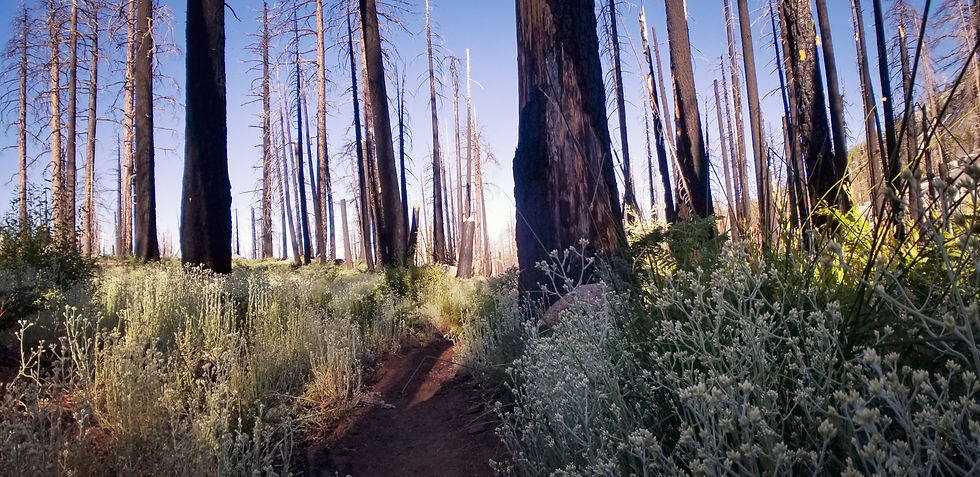
Dead Sea Forest.
Right as I came down into Red’s Meadow there is an expansive sea of dead trees, burnt, cracked and falling over. It’s like a graveyard of trees. I came to find out later that this was due to a fire caused by lightning. Nature’s way of clear cutting. Apparently called the Rainbow Fire which happened many years back, but the effects are still clearly visible today. I deem this area, “The Dead Sea Forest.”

This is the phone I called home on and wept like a baby.
I strolled into Red’s Meadow a giant dirt ball, desperate for cell service and hunger beyond belief. Immediately I turned on my phone to see if I got coverage and… I did not. I was crushed and bummed. I stumbled helplessly into the store and asked if there was a way to make to call. The nice girl at the register told me they had a payphone right outside. I entered $1 in quarters and called my wife. It rang, and rang, and then… went to voicemail. Ugh. I cried on my voicemail to my wife and told her they were tears of joy. I really wanted to hear their voices, to make sure everything was okay and to tell them that I love them so much, I miss them and that I was doing fine and couldn’t wait to be back home. Next I called my mom and the same thing happened, voicemail. I bent over in the phone both and cried privately to myself. I missed my family so much.
I tried to pull myself together, so I decided to start getting laundry out of my pack. My stuff was all over the place sprawled out on a table when a guy came up and asked if I was hiking the John Muir Trail. I said, “Yes,” and he asked if I needed to place to stay. His wife had booked him a room that had two bedrooms but it was just him and he had a spare. I was in shock as this was an amazing gift and at my lowest moment of the trail. This instantly picked me up. A pure, random act of kindness from a stranger. His name is Ben and he’s a great guy.
Despite the beckoning call of the buses at Red’s Meadow heading comfortably back to Mammoth and Yosemite Valley. Standing there I made a commitment to myself that I was going to finish the trail no matter what. But this kind act was the booster I needed and made me feel zero doubt with what remained of the journey ahead.
Ben lives in the Bay Area, like me. He’s a wine distributor and has his own company. We hit it off right away and, after I got settled into the cabin and took a shower to get cleaned up, we went to dinner at the little diner at Red’s. My treat. It was the least I could do for his incredible generosity.
After dinner I did laundry and Ben and I hung out talking until around 10:30 pm. He let me use his cell, which worked, and I was able to talk to my wife and daughter. Whew, this is just the booster I needed to stay strong, focused and pumped to finish.
After sharing some good trail stories and some rum with Ben it was time to hit the hay, rest up and prepare for our reality back on the trail tomorrow morning.

This was the cool little cottage I stayed in at Red’s Meadow.
Sleeping on an actual bed was so nice. In fact, the comforts of everyday life like a table, a chair, a bathroom that can flush, all of it came rushing back so quickly that in the morning when I woke I was somewhat sad to have to say goodbye to all of it and hit the trail again.
Day 11: Red’s Meadow to Davis Creek
“Everybody needs beauty as well as bread, places to play in and pray in, where nature may heal and give strength to body and soul.” - John Muir Miles hiked : 19.6
Ben and I both woke at the same time this morning. 6 am We were up packing our packs and getting ready for the day. He decided to head out before me as he was hiking southbound and I decided to stay at Red’s to grab some breakfast; French toast and two scrambled eggs. It was delicious.
Back on the JMT and I immediately entered Devils Postpile. Right now it’s looking pretty different than the rest of the trail and quite magnificent. If I had to compare it to something I would say it reminds me of Thunder Mountain Railroad at Disneyland.
Yesterday ended with a downhill gift from the trail Gods, today was payback time as it started with an epic uphill climb that never seemed to end the entire day.

Chillin’ and having lunch at Garnett Lake.
Eventually I arrived at Garnett Lake. I thought it was a nice spot for sure with a stunning mountain cathedral backdrop. I soaked my feet and ate my lunch here at the lake, it was nice to relax as yesterday’s pace was a little intense, even for me.

1,000 Island Lake with some good meditation music going.
Then into 1,000 Island Lakes. Another nice spot, but nothing in comparison to Rae or Marie in my opinion.
Finally I decided to stop for the day. The mosquitoes here are the worst yet. Did I set camp on a nest? Literally hundreds of them swarmed around me. I couldn’t even make dinner. I dove into my tent with my food and ate inside my tent. Generally this is not recommended as the smell can attract critters, or bears, but it worked out.
It’s different being on this side of the hike - the last leg of the hike. It was about 10 days ago when I was talking to people who were on the southbound side towards the end of their hike thinking how the hell could they do that. And now, that’s me! It’s refreshing to talk to people who have only been on the trail for 3 to 4 days and I can see the inspiration in their eyes that this place brings out. The JMT is a magical place unlike anything I’ve ever seen in my life. A perfect 10 in every regard, except for maybe the mosquitoes, but I guess that’s yin & yang playing out.
Day 12: Davis Creek to Sunrise Lake Junction
“Here ends my forever memorable first High Sierra excursion. I have crossed the Range of Light, surely the brightest and best of all the Lord has built. And, rejoicing in its glory, I gladly, gratefully, hopefully pray I may see it again.” - John Muir Miles hiked : 26.9
Today I started right on the ascent trail to Donahue Pass. I took my time to enjoy every step today, every rock, every tree as this is the last pass of the trip then down into the valley which will slowly turn into Yosemite Valley and my final destination, Happy Isles. It feels good, definitely bittersweet to be this close to being done. But, I’m ready to be done. I think I have achieved what I set out to do. To be a simple human being. To live with nature, simply and to do it on my own to prove to myself that I can do it. When I was younger I wanted to do this type of trip. I even set out to do it once after college. I packed up some things and started driving. I had no plan of where to go, I was just going to go and see where the world took me. I got to Shasta and camped there and it hit me. I was alone, afraid and I missed my life. The next day I turned around and went back home. I don’t regret that decision, but I always wondered in the back of my mind if I could do this. Go and be free. To be simple, to not have a set place to be and just flow. It feels good and, on many levels deep, I feel like I’ve touched that inner kid spirit and have nurtured it and given it the satisfaction I was searching for.
I was strolling along on the hike when the most foreign thing happened. I heard noises in the distance that sounded familiar to me. I looked out and saw cars driving by. This sight brought a bit of sadness to me as I knew I was coming back into reality that I was going to start easing back into the realities of the modern world. I hiked along the road for a bit and into Tuolumne Valley.
Tuolumne has a little store, a post office and a café. I was so hungry that I ordered 2 veggie burgers, fries, a soda (which I never drink) and a soft serve. Note to self. Never ever eat this much food. My tummy was wrecked and beyond full. Not the best way to feel on the day before my last big push into Yosemite, but, it was a meal I’ll never forget; for better or for worse.
I set up my tent and laid out my sleeping quilt while I waited for my food so it could dry off in the sun. It was another wet night last night.

Soda Springs. Step inside to taste the well.
After Tuolumne I hiked through a beautiful meadow with lots of day hikers and family. I was excited to stumble upon Soda Springs which is a little well that produced bubbly water from the ground that you can drink. I dipped my hands into the water and took a big sip. I’d read about this place some say the water tastes like Dr. Pepper. I think it tasted like a La Croix drink that had been opened and set out for a day or two. Flat, but cool to taste a real natural soda straight from the source.
After Soda Springs the trail goes back into the deep forest and people start to quickly fade away. I’m now back in my element and the climb in pretty intense. I continued on for about another 4.5 miles. It never stopped going uphill. I think this was the trail’s gentle reminder that it’s not easy.
I hiked on until sunset to knock off more miles as each mile I hiked today was one less I’d have to do tomorrow, my final day!

View looking back at Cathedral Rock.
The sun was about the set and I had reached a campsite but it was all granite. I need soft ground to put my stakes in or my tent actually won’t go up as it doesn’t have poles, it’s a tension tent. So, no camping here. I’d have to carry on.
I finally found a spot to stop but most of the light was gone now. I saw there was another tent nearby, but they were already tucked in with lights out. I felt bad as I know they could hear me setting up my tent in the dark, fumbling like a ding dong, blowing up my mattress all the while trying to be a good neighbor. I laid my head down at 8:55 pm. Hike midnight is 9 pm so I was happy I at least honored the hiker protocol of being quiet by 9 pm.
As I lay here in the dark typing this I’m reflecting on the awesomeness of this journey. Remembering all the things I’ve seen and done. Being thankful that my body didn’t give out, that it was strong and that my spirit made it. A hike is 50% physical and 50% mental. Despite some hiccups along the way, I’m very satisfied with how it all turned out.
Day 13: Sunrise Lake Junction to Happy Isles!
“It is easier to feel than to realize, or in any way explain, Yosemite grandeur. The magnitudes of the rocks and trees and streams are so delicately harmonized, they are mostly hidden.” - John Muir Miles hiked : 12.8
Today is the day! My final day of the John Muir Trail! 13 days in and I’m on the last leg. Tonight I will sleep in my own bed at home. I will see my wife and daughter and I’ll eat an amazing hot meal at my dining table. That sounds so surreal to me, but it’s true.

Out on the trail at 5:45 am. The sun is just starting to wake up.
This morning I shot up like a rocket with a big giant smile my on my face. I was up and out the earliest yet; 5:45 am. The thought of getting home lit me up with enough energy to fuel a rocket ship!
With one last smack from the trail it started right off with an incredibly steep incline. I know at some point this trail has to go downhill. Will it ever? Who knows but I’m going at full speed. Here I come!
The Scorched Forest.

The nasty Shredded Razor Plant. Boo!
As I came around a bend I saw it, Half Dome. It was still a ways away but I saw it and I knew this meant I was nearly back in Yosemite. I went through an area that I call, “The Scorched Forest.” There must have been a pretty big fire here not too long ago as there are many burnt trees. But the ground coverage is thriving. My least favorite of the ground cover plants are, what I call, “The Shredded Razor Plant.” It’s super sharp and shredded the crap out of my legs. I didn’t put my rain pants on as I know it would have just ripped right through them. This plant went on for over a mile. I found the best way to get through was just to walk quickly. Trying to get through it any other way did nothing but hurt so I just powered through it.
As I came up to Half Dome camp there were dozens of day hikers who were doing the trip up to the top. My permit did not allow for it and I thought about asking someone if I could tag along on theirs, but I didn’t. I wanted to finish the hike and I wanted to get home at a decent time so I pushed on.
I got to a point where the trail split and said, “Happy Isles 1.5 miles via Mist Trail” or “Happy Isles 3.5 miles via the JMT.” As much as I wanted to take the 1.5 mile trail I couldn’t. I couldn’t finish the trail by cutting out 2 full miles so I made the decision to go the JMT route and finish the official trail. Otherwise, I felt like I would have missed something if I missed this part. Boy am I glad I went the way I did. The JMT trail goes right to the top of Nevada Falls.
I could see the giant falls going over the top into the dense valley and it was massive. The force of the water pushing through the valley and out through the mouth of the fall was epic. The view from here was absolutely breathtaking and majestic.
I’d heard of the Mist Trail and I knew it had a good view of the falls, or so I thought. As I hiked on I realized that what I thought was The Mist Trail, from watching YouTube videos of this part, was actually the JMT part of the trail! Drips from the waterfall drop down on you and as you hike through you get the absolute BEST view of the falls and the valley. I took several pictures from here. The view was mind blowingly awesome. I was also surprised to see very few people on this trail.

I made it to Happy Isles, Yosemite Valley!
After this section the trail has a big downhill switchback into the Valley and it goes on-and-on. Once at the bottom there were 100s of tourists who had come to see the falls from the bottom. I smiled at many of them along the way. They were here to enjoy nature and I was too. I had just walked a total of 245 miles to get here and I was still smiling, still filled with inspiration and enthusiasm.
As I hiked on I came to the famous JMT sign which reads, “Mt Whitney via the John Muir Trail: 211 miles.” That, plus the 34 miles it took to get from Horseshoe Meadow to Mt Whitney, and that’s my 245 miles. I took several pictures in front of this sign and felt an incredible sense of accomplishment.

Yosemite is truly a magical place.
“No matter where I am, either here or there, I am home.” This is a quote of mine that I said to myself when I arrive in Happy Isles. It sums up how I felt at the end of my hike and embodies the spirit of how I’d like to continue my feeling of life going forward.

I made it. I was done with this journey and it is something I know I will never forget and will always cherish. I’m so thankful to have had the time to do it and to have the support from my family and friends.
As I hopped on a bus it drove through the valley. It’s so beautiful here. The sounds of people talking and laughing slowly brought me back to reality. I didn’t talk to anyone, rather I felt like a ghost observing in silence. When the bus dropped me off I walked for a while until I came to my car; whew, it was still there. I put my hand on the car and gave it thanks for waiting patiently for me.

Comments