The Lost Coast Trail
- Bobby Beck
- May 3, 2024
- 15 min read
Updated: Nov 17, 2024

April/May 2024
Total Miles: 52.5 miles
Black Sands Beach to Mattole Beach then yo yo'd back to Black Sands Beach
Why the LCT?
I first heard of the Lost Coast Trail when I was hiking the John Muir Trail (JMT) years back. I met a couple who were finishing the JMT and they were immediately coming up north to hike the Lost Coast Trail. They talked to me about all the research they had done and how excited they were about it.
After I did some research on my own I also became excited to hike this trail. It’s the longest stretch of undeveloped coast in California. It’s truly wild and remote, not to mention only 4 hours north from where I live.
Planning for this hike takes some time as there are areas where the tide comes up which are called “impassable zones.” There are 3 of them and you need to make sure that the days you apply for your permit have tides that work in your favor.
I did get stopped by a ranger at the Punta Gorda Lighthouse who was hiking past that checked my permit, bear canister and to check that I was following proper LCT Poop protocol. More on that below.

Poison oak tips
Despite what I read online, there were only two very small parts of the trail that had poison oak. There is a bush that has, “leaves of three” that are reddish green and shiny, but the edges are slightly jagged, they grow in a bush-like fashion and are in direct sunlight. It’s important to remember that poison oak does not like direct sunlight. It likes to be near moisture (water) and in the shade and it is more vine-like than a bush.
Going southbound from Mattole to Black Sands Beach the two sections that had poison oak were 1) just after the Punta Gorda lighthouse in an area that has a bit of tree coverage and a small stream running through it (barely any in this section) and 2) just before Big Flat. It’s after you go UP the steep sand dune, perhaps the sharpest gain of the hike. This section had a bit more oak that grew out onto the trail and had some vines without leaves. The vine/branches carry the oil so just be careful not to touch them. I took a stick into that section that I picked up a ways back and used that stick to move the oak away from touching me.
You can always use your trekking poles to move unwanted oak branches out of the way, but then you risk getting the oils on your poles and thus onto your hands and onto your body.
Also, I had a small bottle of Tecnu (poison oak cream) and treated my hands and forearms with it after both of those sections just to be extra careful. I do get poison oak bad so I just wanted to be extra safe.
The good news is that, after those two sections, you are free and clear of poison oak on the trail. Yay.
Ticks tips
If you don’t like hiking with tall grasses rubbing up against your legs and body for fear of ticks then this hike is not for you. The section from Mattole to Big Flat is covered with tall grasses. I did a tick check every so often and luckily made it through the hike tick free. Here are some tips I hope help you out.
Spray your shoes, gaiters (super helpful to have), pants and trekking poles (from the mid section down to the bottom so you don’t get the spray on your handles) with permethrin. I use the Sawyer brand which you can get at REI or online. When you spray your pants be sure to spray the knee to ankle area extra good as that is the most likely place to get them. You can also spray your tent, pack and shirt if you want to be extra careful. I did spray my shirt and pack but didn’t spray my tent this time around. I don’t feel like that was necessary.
Another tip I have is that you can brush your trekking poles up against the sides of the grasses as you walk past, left pole/foot, then right pole/foot. My thought is that this can knock ticks that may be poised to jump on you off with the poles and, if they decide to jump on the poles, you’ve sprayed them with permethrin so they’ll just jump off. That was my technique and, for whatever it’s worth, it worked for me.
LCT Poop Protocol
The ranger I ran into confirmed with me that the proper way to go #2 on the trail is to go out to the beach when the tide is low(ish) and dig a hole in the sand, do your business, bury it, then be done. I asked her why this was the protocol and she said it’s so that at high tide the water will take the waste and carry it out to sea. Since we all share the same handful of campsites and water sources it’s better to have the waste go into the oceans than to contaminate the creeks on the trail. She also mentioned that this is another reason they issue so few permits as they don’t want to waste contamination to be impactful to the ocean environment.
I use a trail bidet so I don’t have waste to pack out, but if you use toilet paper you must pack that out.
General Tips
Tip: Going from Mattole to Black Sands Beach I would highly recommend wearing pants. Generally I always hike in shorts, but, because of the poison oak and tick situation, I opted to wear pants and am glad I did. From Big Flat to Black Sands Beach there is no more oak or grasses/ticks to worry about and I wore shorts in that section.
I hiked the trail in both directions from Black Sands Beach to Mattole then back to Black Sands Beach in 3 days. I had perfect weather and my tide planning worked out perfectly.
Tip: 1 liter of water is plenty for this trip. There are plenty of water sources throughout the entire hike. Some of which just fall from the mountainside down onto the beach. I carried an extra half a liter of water for washing my hands and using my trail bidet.
Tip on communication: Zoleo
Note: The trail is varied, but flat overall. There isn’t a lot of elevation gain on this hike and I didn’t break a sweat on the entire trek as it’s generally cool overall.
Food on the LCT

I planned for four full days of food
Day 0
Driving up to Shelter Cove is about a 4 hour driver from my house. The drive up is quite beautiful and the closer you get to Shelter Cove the more rural and private it becomes. When I arrived I went to the Black Sands Beach parking lot and walked down to where I’d be starting the trail tomorrow.
As I came around the corner onto the beach the Lost Coast exposes itself in all its glory and my jaw just about dropped to the ground. It’s absolutely stunning! Tomorrow, I’ll be starting my adventure on this trek and I’m so excited.
What makes this hike more difficult is that you need to be very aware of the tides because there are three impossible zones, which means at high tide you can not pass in those areas, and you want to do your best so that you’re able to get through those zones with enough time before the tide shifts and starts coming back up. People have lost their lives hiking this trail for this reason so it’s important to be respectful of the necessary planning and safety precautions.
Also, the terrain is tricky in that the sand isn’t just like sand on a normal beach. In some areas there are thousands of rocks that you step into and they slow each and every step down.
Finally, there are other critters like bears, snakes, ticks, poison oak and high winds in the day and into the night to be aware of as well.


Some snaps in the town of Shelter Cove
When I got to town, I had plenty of time to spare. The town is quite small and there is not a lot to do. There are several restaurants, but they are all fairly spread out and far from one another. I ate at a restaurant called Gyppo Ale House. The food was really good and the view was outstanding. There’s a little private airport right in front of the back patio and the beach just beyond that. I did get to see a small plane land and another one takeoff while enjoying my dinner. Pretty cool!
As I was eating, I looked across the way and saw someone setting up a tent. After I finished eating I went to this area and found the Shelter Cove Campground and I asked the front if they had any sites available. They had tons of spaces available and I was able to book one on the spot for $25 for the night. This was great as it put me about five minutes from the trailhead and I wanted to be on the trail for day 1 around 6 AM.
It was fairly windy that night and rather cold. I decided to sleep in my car so that I didn’t have to pack everything up in the morning. But the cold and wind outside were giving me a taste of what was to come on the trail. I called home on WhatsApp then I was off to sleep around 9:30 PM.
I used Whatsapp as it works well with WiFI. They have WIFI at the campground as the cellular connection in Shelter Cover is not available.
Day 1 (17.5 miles) Black Sands Beach to Randall Creek
I stepped out onto the beach at 6 AM on the button and it’s a beautiful day. There’s absolutely no one around. The trail is all fresh with no footprints as the ocean and wind wipe them away every day.


The sand is a little tricky as you sink with each step, but you get used to it pretty quick. The visual and the sound of waves crashing right next to me is amazing. I can’t imagine such a beautiful place without so many people here. Where are they? Don’t they know about this place? There’s absolutely no one here. It truly is the Lost Coast. A perfect secret tucked behind this massive National Conservation Area.
On my left I have crashing waves and on my right, giant tree lined mountains with the middle, for as far as I can see, is where I’ll be hiking. It’s so clear and quite cool that you can actually see so much of the trail ahead of you. It just seems to go and go.
I’m now about 3 1/2 miles into the trail. The theme that quickly came to me for this hike is, “alone with my thoughts.” Although that might seem like the theme of most hikes, it really isn’t for me. Being present on all hikes is something I try my best to embrace, and this hike I wanted to embrace what seemed to be unfolding for me. Much presence and gratitude.
Right past Gitchell Creek. I saw a line of fresh bear prints along the beach. They were definitely from this morning. It was the only footprints I could see. I took a quick picture then kept on walking with a slightly enhanced pace.
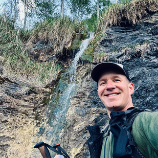
People weren’t kidding when they said you could bring 1 liter of water on this trek. There are tons of little streams along the way, some of which are absolutely stunning with several tributaries cascading down into one fall billowing right out onto the beach. It’s truly nature’s gift and a welcomed one to us hikers.
When preparing and researching for a hike everything seems so elusive. Then, once you get out on the trail, everything immediately starts to make sense. For instance, Buck Creek, Shipman Creek, etc., are all, as they state, creeks, i.e. water sources. So every time you see “creek” listed on the map, that is a fresh water water source. That seems obvious but when I was planning, I didn’t quite think about it like that. I’ve hiked plenty of places where “creek” is nothing more than a dried up dirt patch, but that is not the case on this trail.
Kings Range provides a tremendous amount of shade throughout the hike in general. I didn’t even get my first ray of light until I was around Shipman Creek around 8:40 AM. And although the trail was extremely cold this morning when I started, as soon as I started hiking, I quickly warmed up and stripped down to my base layer and I’ve been totally fine ever since.
The terrain, so far, has mostly been in the sand on rocks. After Big Flat, a lot of the trail is up on the bluffs on hard packed ground. The trade off here is that you are hiking through tall grasses and need to do tick checks from time to time.
At Big Flat there is not, at least to my knowledge, a way to get across without getting your feet wet, so I just went for it, about ten minutes later they were almost completely dry. The stream here is deep in parts. Deep enough to swim while being able to still see the bottom through the clear water. I didn’t do this on my way to Mattole, but did wind up swimming here on my way back. The water is cold, but refreshing and welcomed after a long day of hiking.


There’s a cool house just past Big Flat. It looks like a private residence. It's a fairytale-like wonder out here in the deep seclusion of nature. I wonder who lives here? How often do they live here? What type of life do they have living out here? The only way out here, that I can tell, is to hike the 8 ½ miles in. There were three deers grazing peacefully in the meadow in front of the house and, as far as I could tell, there were no people in the house.
Coming into Spanish Flats I saw a snake lying directly on the trail. It was about 3 ½ feel long and yellowish brown. No rattle on the tail… whew. it was just laying there. At first I thought it was dead, so I took my trekking pole and gently tapped it on the side and it slithered away quickly into the tall grass. Okay, now I’m really feeling a heightened sense of awareness for what other critters are just waiting to slither out.


There are a ton of grassy areas after Big Flat. I’m on tick patrol which means I check my pants after every large section of grass. It might be a bit overkill, as I haven’t seen anything yet, but it’s good just to be safe.
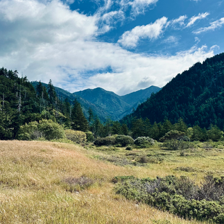
The mountains around Spanish Flats are covered in grass instead of trees and, as the wind blows furiously, the grass on the hillside dances in beautiful waves.
I arrived at Randall Creek around 2:20 PM. I could’ve kept going to Cooskie Creek, but I wasn’t sure as that was right in the middle of one of the impossible zones and safe tide hiking stopped at 3:15 so I didn’t want to risk it. Also, I hiked 17 1/2 miles today, which was my goal, so I decided to set up camp and chill out for a bit. It was nice to take a little nap in my tent, too. I have never had that much time to myself at a campsite while on trail. I dug it overall, but wouldn’t have minded hiking another hour or two.


I ate dinner down by the creek and enjoyed the ocean’s performance as the waves crashed just in front of me.
I really dig Randall Creek. There are several campsites here (3 -4), but I’m the only one here tonight.
The wind is howling and my tent is thrashing about. It’s holding up okay, but some gusts make the walls of my tent push out and then slam back onto my head and feet. Thwack! It’s going to be an interesting night.
Day 2: (26 miles) Randall Creek to Mattole then back to Big Flat
I was on the trail at 7:05am this morning. Day 2 on The Lost Coast Trail. Wow this is a magic morning. The weather is perfect and the beach in this section is outstanding. There’s absolutely zero people and zero tracks again. I love how the tide washes away everything so it feels fresh and like I’m the first person to ever walk in the section. It feels amazing and so special.
Off in the distance I saw a giant rainbow stretching across the sky down to the mountain side. WOW.
In this section there are rock walls with intricate patterns on them. Today is awesome, I slept well and am feeling great!

As I walked past Cooskie Creek there was a large group of people who were breaking down camp. It was quite crowded and looked like it could’ve been a lot of fun for a social hang out. However, for me, this trek is more about solitude in this incredible place. I said, “Good Morning” and headed on.
I was walking along the trail when I heard a loud, “DERP!” and, all of a sudden, there was a giant elephant seal on the trail! I popped it’s head up to say, “Hey, this is my trail!” I was a bit startled, but I got the picture and saw an alternate trail through the tall grass so I quickly backed up and took that route instead. “You can have your trail Mrs. Elephant Seal.” I thought to myself.


The elephant seals are scattered about just before the Punta Gorda lighthouse and they are very friendly with each other. In fact, they love to nestle up and there’s a group of about twelve huddled up together again, directly on the trail, so I continued on the alt path up to the lighthouse.
The Punta Gorda lighthouse is incredible! I didn’t know you could climb up the stairs and stand on the top and look out. It’s really pretty and a nice place to take a little break.
It was rather windy today overall, but the mountains and cliffs hug you and protect you. However, a handful of times I came around a corner and a swift gust almost knocked me off my feet. It’s very strong today.
The last section coming into Mattole is really slushy sand and slow going. There’s a trail up on the bluff that you can walk on, but it’s still very sandy and it sinks with each step. But it was great to reach the finish line.
I arrived at Mattole at 11AM. Took a break, ate some food, stretched then put my pack on and headed out for the second half, the return section of my hike. The part that was a little slushy before seemed a lot easier to walk through. I think it might be because I’m rested and have food in my belly. Here I go!

What an incredible place this is. Having completed the hike one way I can honestly say I’m excited to go back and see it in reverse. I know what to look for, what to expect and can take it in even more as I head back, plus, heading back things look enough different to not feel like it’s the same exact hike.
Heading back I ran into a ranger at the lighthouse. She checked my permit and to make sure I had my bear canister. She also checked to ask if I was pooping correctly on this trail. More on that above.
I walked and I walked, right past where I started this morning at Randall creek. I decided to hike to Big Flat as that is just about as far as I could go as the last impassable zone is now impassable and I’ll go through that tomorrow morning.
The stream at Big Flat is really nice and you can swim in it. It’s deep enough. I hopped in and took a swim and a little trail bath. It felt really nice to be clean and fresh, then drip dried in the evening sun.


I set up my camp and ate food with a great view of the sunset and mountains. All done and ready for sleep. There was one other couple there. I camped away from them to give them their privacy. They invited me to enjoy their evening campfire, but I said, “Thank you” but I was going to head to bed as I was pretty tired.
I’m looking forward to the last section tomorrow morning!
Day 3: (9 miles) Big Flat to Black Sands Beach
I got on the trail at 7:15 AM. The tide doesn’t cool down in the section until around 7:45 this morning, but I have a little bit to hike this morning before I get there. It’s a beautiful day again! Three beautiful days on this incredible trail. I’m so grateful.
Snakes are something you have to think about on this trail and so far I’ve seen two. Luckily both were not rattlesnakes but still it keeps my senses perked and alert. Another thing about snakes is that at Big Flat there’s all these dried up pieces of seaweed scattered all around and they look exactly like snakes! Since rattlesnakes are such a concern that is talked about when planning this trail on the Facebook group and blog posts, it’s almost like, in this section of Big Flat, that nature is playing a joke on us hikers to keep our senses alert ;)


As I make my way back, it hits me, I haven't spotted a single boat, ship, windsurfer, kiteboarder, jet ski, or any man-made object in the ocean during this entire journey. This solitude truly makes this place feel exclusive and unique. It's just me, surrounded by nature's elements.
Today feels exceptionally serene. The sun hasn't risen above the mountains yet, and there's a stillness in the air. The ocean waves are gentle, allowing me to soak in the peaceful sounds and ambiance. Moreover, I haven't encountered any other people today. In fact, throughout this trek, I've only come across around ten other people, a few small groups, the ranger, and a couple of others I passed by. This seclusion is what makes this place incredibly special, it's a retreat away from the hustle and bustle of everyday life.
Out here it’s just me with my backpack and everything I need to survive inside it. This is the most simplest form of being a human these days. “Alone with my thoughts” has become the guiding mantra of this trek, leading me through every step.
As I look back on these final miles, I'm overwhelmed with gratitude for my incredible life, a loving wife, a precious daughter and supportive parents. Life is indeed a precious gift, and moments like these, sleeping under the stars with the gentle sound of the wind, remind me of its beauty. Nature's playground is truly magnificent.


If you’re contemplating hiking The Lost Coast Trail I highly recommend it. Overall, I didn’t find it to be an extremely difficult hike, but it is definitely a meditative and peaceful experience. I think that’s really what I was hoping for on this hike and it definitely delivered. All the best to you on your journey, and I hope this inspires you in someway to get out and adventure more.


Thanks for sharing! I did the hike 6 years ago and am finally going back this weekend. It’s my favorite backpacking destination near the Bay Area. Based on the email I got from the BLM today, I think you might have seen elephant seals, not sea lions! I’m excited, we only saw seals last time we did the trip.